Registration & Admission
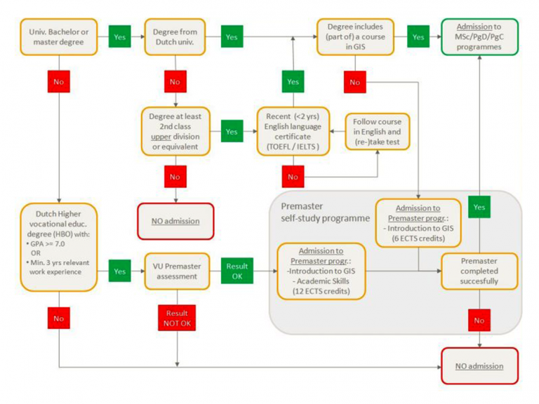
Next to the Master programme, UNIGIS also offers academic postgraduate programmes on Master level. Courses start in September of each year. The maximum number of students per intake is 20. The same entry requirements apply to all three programmes: Students need to have obtained an academic bachelor level through previous education, including a GIS-component, in order to enter the course. You can use this flowchart to see whether or not you have direct admission to the MSc/PgD/PgC programmes or what other steps you may take to get into the UNIGIS programme.
Application forms
The Master’s coordinator receives and evaluates the applications and advises the Examination Board on conditions for admission. The board reviews the application and the advice and decides if the applicant can be admitted and under which conditions. The applicant will then receive a letter of admission, which allows the applicant to start his or her study in September or Febuary.
Required documentation for UNIGIS application
Next to the application form, the following documentation is required:
- Completed application form
- Curiculum Vitae
- Diploma(s)
- Transcript of grades
- Motivation letter
- Scan copy of Passport / National ID Card
- Description of courses relevant to the UNIGIS programme, if they are not clear and/or explained on your transcript or in your motivation letter
- Evidence of language training, in case prior degree was not in English (see requirements below)
Application deadlines
Deadlines for applications are as follows:
- Current students at VU University Amsterdam: 15 August
- Students with a Bachelor's, Master's, drs, mr or ir degree obtained at a Dutch University: 15 August
- Students with a Bachelor's or Master's degree obtained at a University outside the Netherlands: 1 August
- Students who need an admission letter for a fellowship (e.g. NFP) on 15 February latest: 15 December (only for September-intakes)
- All other students (including students from higher vocational education): 1 August
Language Requirements
VU University Amsterdam requires international applicants to take an English test and to submit their score as a part of the application. Exceptions are made for students who have completed their education in Canada, USA, UK, Ireland, New Zealand or Australia or who have obtained an international Baccalaureate or European Baccalaureate diploma.
The minimum English language proficiency requirements for admission to a Master's programme at VU University Amsterdam are:
-
- IELTS: 6.5 - please note that candidates must take the Academic test and not the General one!
- TOEFL paper-based test: 580
- TOEFL computer-based test: 237
- TOEFL Internet-based test: 92-93
- Cambridge Certificate in Advanced English (CAE): A, B&C
- Cambridge Certificate of Proficiency in English (CPE): A, B&C
For TOEFL, IELTS, and Cambridge Certificates, the test must have been completed no more than two years before 1 September of the year in which your course starts.
Admission requirements
A student can only be directly admitted to a UNIGIS academic programme if he/she has obtained a Bachelor or Master degree or equivalent previously. All applications will be assessed by the Examination Board. Students from all disciplinary backgrounds will be considered, but you should at least have completed one course relevant to the programme (i.e. a course including a GIS-component) on an academic Bachelor level. In addition, the course requires sufficient mastering of the English language. The Examination Board may ask the student to provide proof of his/her English language skills. Students with the following degrees are considered for admittance:
1. Admission with a Bachelor's or Master’s degree from the VU University Amsterdam or any other Dutch university
If you have already completed a Bachelor's or Master’s programme in a subject related to Geographical Information Sciences, your curriculum will be examined to decide if you can be admitted to the programme directly or if you need to take additional subjects to bring you up to entry level. The Examination Board will make the final decision on your admission. For more information, please contact the Master’s coordinator Niels van Manen (n.van.manen@vu.nl).
2. Admission with a higher professional qualification (hbo) or international equivalent
Students with a higher professional qualification (with a minimum of three years of full-time study) need to have a Grade Point Average (GPA) of at least 7.0 or have at least three years of relevant work experience. They are first required to take the Premaster programme (12 credits) to bring them up to entry level. Furthermore, sufficient mastering of the English language is a prerequisite to admission. Based on the results from the Premaster assessment, the Examination Board may ask the student to provide proof of his/her English language skills (for example in the form of TOEFL- or IELTS-test results). After succesfully completing the Premaster programme, students can start with the UNIGIS PgC/PgD/MSc programme.
3. Admission with a Bachelor's or Master's degree obtained at an institution outside of the Netherlands
Students who hold an equivalent degree obtained at an institution outside of the Netherlands may be admitted to the Master’s programme in Geographical Information Sciences at the Vrije Universiteit on the basis of a decision to that effect taken by the Examination Board of the Master’s programme. The Examination Board will determine whether the foreign qualification in question is sufficiently relevant to warrant direct admission to the Master’s programme in Geographical Information Sciences. The Examination Board may make additional demands of the student before granting admission to the Master’s programme. Please note that a Bachelor’s degree with lower Second division does not meet the requirements.
Note: No residence permit for international UNIGIS students
Before you decide to apply for the UNIGIS programme, please consider the following: The VU University Amsterdam has an agreement with the Dutch Immigration Service (IND) through which the university can apply for residence permits for its students. In order to be eligible for a residence permit during your studies, a student must be enrolled as a regular full-time student or as an exchange student. For a part-time, distance-learning study like UNIGIS, students do not have to reside in the Netherlands. Therefore the VU University Amsterdam cannot apply for a residence permit for UNIGIS students.
Premaster assessment & Premaster programme
At VU University Amsterdam, students coming from higher vocational education (hbo) must take a Premaster assessment. The outcome of this assessment is not binding for admittance, but it will be an important criterion for the Examination Board. See for more information Premaster assessment for students from Hogescholen (only available in Dutch). In some cases an additional programme may be prescribed for students, e.g. introduction to GIS, or courses on research approaches (methods and techniques) and scientific writing in English. In general the Examination Board requires a premaster's programme for students with a Hogeschool Bachelor's degree. This programme includes the following courses:
- Introduction to Geographical Information Science (6 ECTS credits)
- Academic Skills (6 ECTS credits)
Recommended literature
We recommend that students admitted to the programme prepare for the courses by reading an introductory textbook in geographical information sciences. The following title is particularly useful:
- Longley, P.A., Goodchild, M.F., Maguire, D.J. and Rhind, D.W. (2005/2011), Geographic Information Systems and Science, second/third edition, John Wiley & Sons, Ltd., Chichester, England
Other useful books include:
- deSmith, M.J., Goodchild, M.F. and Longley, P.A. (2005), Geospatial Analysis, A Comprehensive Guide to Principles, Techniques and Software Tools, second edition, Winchelsea Press, England
- Scholten, H.J., van de Velde, R.J., van Manen, N. (2008), The role of Geo-ICT and Spatial Approaches in Science, Springer, Dordrecht, pp.133-161